Monday, September 29, 2014

The Purpose of a Sign

By Beth Sullivan.
A few weeks ago, we emerged, hot and sweaty and dirty from a work effort on Knox preserve. We were met by a woman and a young child looking for a place to spend some time hiking and found themselves on Wilcox Road, parked behind us and planning to walk into the preserve.
It takes a team to erect the big signs that make Avalonia preserves.


The Osprey on Paffard Marsh benefit from the protected land.

She asked if we were with Avalonia and wondered if she could ask some questions. Well..of course!!

A chance encounter...

Turns out that Ellyn Santiago is a Westerly Sun reporter who travels the roads of Stonington regularly and had noticed the big new sign on Paffard Marsh. She had always loved the marsh and its family of osprey and was pleased to know it was forever preserved. This began a line of questioning about signs: how we choose names, how do we acquire property, why do we want signs on the properties and what do we want people to know about Avalonia.
Dean Avery Preserve is a small, scenic gem.

You start your hike down into the Stone Bridges trail here...

leads to an article...

Each of those questions could take a full page to answer, but what she came away with was an understanding that we, Avalonia, are proud of all the properties we have acquired, no matter how they have come into our hands. Each one has a story. By putting our signs out on the land we can proclaim proudly, that this land is preserved for you, the public, and future generations to enjoy and appreciate. Whether you walk a trail or sit in your car with binoculars watching the osprey, it will always be there for you and your children and grandchildren to enjoy. Because Avalonia is all volunteer and member based, we rely on our members’ generosity and our donors’ gifts to support all our activity. Land has great value and does not come cheaply in this part of the state. Every acre is cherished. Our stewardship is carried out with thought and care. We often spend our own money on wood and paint for those signs, and spend free weekend days to set them in place, just so they can be visible to those who pass by, like Ellyn. Just maybe they will bring in new members, or another donation, or just a passing thought of gratitude that the beautiful marsh land is preserved forever.
And end up here.

about our signs.

Here is a link to the article Ellyn wrote and we are grateful for her efforts. 
Wequetequock Cove Preserve sports this sign.

Wequetequock grasslands


Photographs by Beth Sullivan and Rick Newton.

Sunday, September 21, 2014

Knox Family Farm: By Hiking or Paddling

by Beth Sullivan
We paddled up Quimabaug Cove last week: a gorgeous September day, light breezes, warm sun, just perfect. From the water you get that whole different perspective of the edges of Avalonia’s Knox Family Farm Preserve.
The Avalonia Preserve begins at the far side of the field, marked by the welcoming sign.

By water

Maybe about a half mile up from the Route 1 overpass, the houses thin out, and the marsh grasses soften the edges. The clear water allows glimpses of rocks and shellfish and crabs along the bottom. On the East side there is a small cove lined by saltmarsh. At this time of year the grasses are at their best, some with their unique flower spikes. There are small Saltmarsh Asters, Seaside Goldenrod and lovely Sea Lavender. On this day thousands of Green Darner Dragonflies flew by, on a mission, heading across the cove as they continued their southern migration. We startled a Great Blue Heron…actually it startled us as it jumped into flight with a raspy guttural croak.
Salt Marsh grasses and asters can be found along the edges of the cove.

A Great Blue Heron blends in as he quietly stalks small fish in the marsh.

Just beyond the cove the land rises up: a geological formation of rocky cobble, like an esker left by the glaciers. Look for the Avalonia sign there, and pull onto the little rocky shoreline spot. You can tie up the boats to a cherry tree by the water, but likely they won’t escape. It is a little steep, but we hope to put up a railing, and the trail is at the top of the hill.
A shady rock just off the trail provides a great observation point.

There are two loop trails on this portion of the preserve. One takes you along the waters’ edge and gives lovely peeks through the cedars, to the water, and marsh below. It makes a great spot to watch the birds, wait for the Heron to return or listen for the rattle of the Kingfisher. The old cedars tell a tale that this was a pasture that grew in long ago. There are stone walls and piles of small rocks that imply that clearing the land was no easy task. There is a junction, with maps, where the trail meets up with an old roadway. There is interesting history here, an old “casino” was located in this area, and that will make for another story. The loop is easy walking, the trail is wide, well maintained and clearly blazed in yellow, thanks to a volunteer and his family. We have hopes to add another loop that will take a hiker into the rockier and wetter north portion of the preserve.
Old Mountain Laurels line the trails
It is a nice way to stretch your legs before you return to paddle.

By land

To visit from the main entrance: park on the mowed grass at roadside near Darling Hill Farm, opposite Lord’s Hill on Rt. 1. Please note, the driveway is PRIVATE; the entrance to the trail is on your right, and this portion of the trail is a Right of Way to get to the actual preserve. It winds though a wet woodland with massive old Mountain Laurel shrubs, ferns and grapevines. A boardwalk takes you over the really wet areas which are full of standing water and even frogs in the spring time. Along the upper stone wall the trail goes through head high shrubs and golden rod and comes out by the Farm shed. The rope way is not to keep walkers out, but to keep the pony in! Please be respectful of the landowners as you walk in front of the shed and go right at the corner though a gateway in the wall. This will get you to a lovely field of grasses, milkweed and butterflies. Enjoy as you follow the edge to the far side where the Avalonia Owned property begins at the trail head sign. There you pick up the yellow blazed trail on the pentway.
A boardwalk protects the wetlands.

Either way you experience it, Knox Family Farm is worth the visit.
The little cove provides a quiet place to sit and observe.


Photographs by Beth Sullivan.

Monday, September 15, 2014

Second Call for Artists and How Everyone can Support The Art of Conservation

By Beth Sullivan
About a month ago I challenged everyone to get out on a preserve, hiking, or even kayaking, and suggested that rather than just enjoy the view, you somehow record it: by photography or some other artistic media.
Well..how did it go? You still have time. You can see the rules and guidelines here, and entry form as well. The invitations will be in the mail, but please keep an eye on Facebook and the evolving website for more details.


We are putting the event together and we can use your help in several areas: 
  •  Before the event we will need some staff to receive the art at our 6 Hatch Street office in Mystic. There will be labeling and sorting to be done.
  • We are looking for additional judges, to review the artwork and photography and children’s entries.
  • We will need teams of helpers to set up for the event at the Mystic Arts Center: tables and easels, art work and photography, kids’ gallery and main galleries. There are silent auction tables and live auction displays to be managed.

During the event we will need volunteers circulating in the audience during the live auction, to bring attention to bidders. At the end of the silent Auction, we will need people to help process the sales and make sure the right Art Treasure goes home with the right buyer.
If you enjoy this sort of fun, or have had experience hustling and bustling…please join us!
After the event, of course there is clean up. We also need to assure that contest art work and art work that is unsold will be returned to owners.
There are numerous other ways you can help us. Avalonia is not just about stewardship; it takes a lot of work to raise the money needed to create a Bedrock Fund, dedicated to future acquisitions. In June the fund was used to finance the purchase of Babcock Ridge in North Stonington. Now we need to restore the fund. Your donations of art, entry into the contest, attendance at the event and in particular sponsorship for the event will help us rebuild the fund for those lands we hope to acquire in the future. 
Please contact Heather Milardo in the Avalonia office, by email (avalonialc@yahoo.com) or phone message (860-884-3500), to let her know how you can help. She will be setting up assignment sheets with time blocks and can let you know when and where we need you most.

Certainly the most fun is to get out there and create art!!


Monday, September 8, 2014

Avalonia by Kayak

By Beth Sullivan
Many of Avalonia’s preserves include a water feature. There are ponds, marshes, streams, even rivers. You can walk along or around or even through many of these, but along the shoreline there is a better way to enjoy the view: by kayak. With the end of summer very near, crowds are diminishing, colors are intensifying, migrating birds move along the shore on their way south, and some butterflies and dragonflies stage migrations over water along the coast.
Monarch Butterflies will find Seaside Goldenrod, then migrate over open water.

Many of our coastal preserves are marsh lands, and it is difficult and unwise to walk on the fragile salt marsh. Usually the closest you can get is a glimpse from the road. You can peek at lovely Cottrell Marsh from Latimer Point Road. Woolworth Porter Preserve has a small path through the woods, in from Wamphaussuc Road to view the marsh. But to really appreciate the expanse of grasses, the wildlife along the inlets and over the land, it is ever so much better to view from the water.
A quiet overlook of Woolworth Porter Preserve. 

Sandy Point

Sandy Point is an island, so of course you need a boat. Put in from Barn Island boat launch and paddle across little Narragansett Bay, and you can pull up close to shore and either paddle or wade, towing your boat along the North Shore. Now you can observe the staging of migrating shore birds, sandpipers, plovers and terns. Some of them are protected species, so avoid undue disturbance. Also from the Barn Island boat launch you can head far east to find the Continental Marsh Preserve, or go west and up the cove to see the Wequetequock Cove Preserve and meadows.
Sandpipers flock on Sandy Point.

The grassy fields of Wequetequock Cove Preserve.

Wilcox Road

Another launch spot is a small access area on the side of Wilcox Road, off Rt 1 in Stonington. From there you have some choices. Paddle under Rt 1, up the Quiambaug cove, and on the east shore look for Avalonia Land Conservancy signs. The Knox Family Farm runs along the cove for quite a ways and includes a small inlet area. We hope to make an official landing spot there so visitors can get out and walk the trails as they wish.
You might encounter a Snowy Egret along the Quiambaug Cove.

Back at the launch, nearly the entire west shore, except the Cemetery edge, is the Knox Preserve: a totally different vantage point. The rocky shores are so different than the mowed trails. When the tide is low you can get onto a small beach that is hard to reach from the trail, due to massive poison ivy patches.
The rocky shoreline of Knox Preserve.

Paddle under the Rail Road Bridge and head east, around Lord’s Point, and the next big marshland area is the Woolworth-Porter Preserve. From this angle you can see the beautiful greens of the marsh grasses and can head up a little inlet or creek and wind deeper into the preserve which actually extends quite a ways north, to the rail Road Tracks, but the water way doesn't extend very far.
The channels can be navigable when the tide is high

For a longer trip, from the same launch site you can head west along the shore and out and around Latimer’s point, remembering that the Knox preserve is just on the other side of the tracks. Look for the osprey nest high on a pole. West around Latimer Point, you will come to another large marshland area. This is a big expanse of Cottrell Marsh which extends all the way over to Mason’s Island Road. This area has some interesting high islands with trees and shrubs where Herons and Egrets love to roost at this time of year.
Off shore from Knox Preserve you can see Osprey nests and other waterfowl.

Fall colors are outstanding along the Cottrell Marsh.

Simmons Preserve 

Go through the gate at the Simmons Preserve, on North Main Street in Stonington, to a little access area onto Quanaduck Cove. You can paddle under Rt 1 and find yourself at the marshy southern tip of Paffard Woods.
Through the gate at Simmons Preserve is access to the Quanaduck cove.

Getting out on any of the marsh areas is really not encouraged. The ground can be quite unstable and habitat fragile, and there are several species of birds that are in need of protection during nesting season.
Take note of what a wonderful buffer the marshlands are, protecting the upland from storm surges and tides and providing a sanctuary for all sorts of wildlife. Avalonia is dedicated to protecting and preserving the marshlands along the coast line. Enjoy the view from the water.

Photographs by Beth Sullivan.

Monday, September 1, 2014

High Summer in the Meadow

By Beth Sullivan
While the season is at its peak, everyone needs to spend some time in a high summer meadow. The woodlands are quieting, uniformly green now and drier. Spring wildflowers are long gone and most vernal pools have dried up. But the excitement can be found in the open fields, those not hayed or mowed, but allowed to grow naturally and wildly. Most fields that have been host to nesting grassland birds are more accessible now. The nestlings have fledged and it is less likely that anyone walking into a field will disturb young birds or mammals. From a distance the fields look flat and open, but walk closer-those plants can be shoulder height or more!
Monarch Butterflies seem content to share Joe-Pye Weed blossoms.

Fennerswood, on North Main Street, has several small fields that can be seen from the road but difficult to really access. You can see the haze of pink and yellow of wildflowers over the green grasses.
Knox Preserve’s fields continue to evolve. It was only four years ago that they were farmed for corn. Each year the grasses and flowering forbs increased in spread and variety. While there are still non-native flowers there, for instance Queen Anne’s Lace, even those provide nectar and food sources for numerous insects and seeds to follow and will be enjoyed by other animals and birds. Now there are Goldenrods, Asters, Fleabanes and Milkweeds among others. Swallows and Purple Martins cruise the fields for insects.
But, let me suggest a new exploration: the Preston Nature Preserve. Left off of 164, just north of the intersection with 165, is Krug Road. One half mile down Krug Rd, on the left, is a gateway and Avalonia sign. Parking is tricky, but you can get off the road. Enter the preserve and decide your course-clockwise or counter clock wise. It is 55 acres of mixed habitat. There are woodlands, some showy rock formations and glacial erratics, low wet areas and a couple of ponds that while low in volume, still host some turtles and frogs. But the real beauty of the preserve is to be found in the numerous meadows.
A shady bench provides an enjoyable meadow view.

The path runs through a meadow of Milkweed.

Avalonia has owned this land since 1989, but only in the last several years has there been an active plan to manage the successional growth and curb the spread of the invasives that seem to threaten every inch of available space. Efforts are ongoing to remove or at least control the invasives and promote native grasses and flowers in the restored areas.
The birding was good along the woodland paths.

Cedar posts, barbed wire and horse shoes hint at a farming past.

On a recent hot August day, we were thrilled to see good numbers of Monarchs floating above the masses of pink Joe-Pye-Weed. Monarchs have been scarce this year, yet here they have found nectar sources and acres of milkweed on which to lay their eggs. There were Fritillaries, Swallowtails, Skippers and hosts of other butterflies as well. Bees and wasps ignored me as I walked deeply into the tall flowers. Goldenrod, several species, at different stages of flowering, added the beautiful bright yellow to the scene. Birdlife was abundant as well with Flycatchers, Bluebirds and families of Chickadees along the edges and hawks soaring above the open areas.
Shoulder high pink and gold.

A family of Chickadees stayed along the meadow edges.

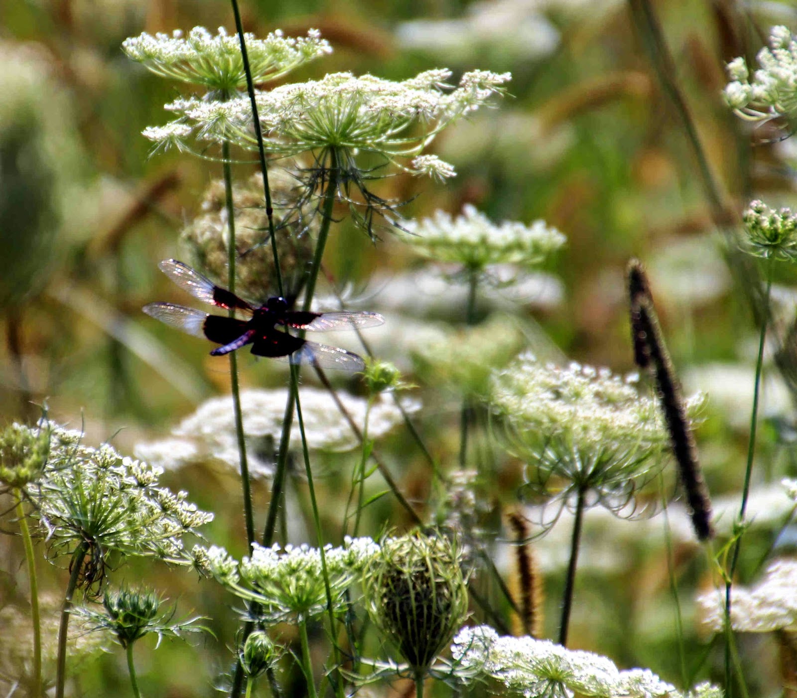
Queen Anne's Lace attracted this dragonfly.


The trails are not marked, but they are well mowed and woodland trails are hardened and easy. They all interconnect and loop together; you cannot get lost, except in the beauty of the mid-summer meadows. Enjoy.